Cape Reinga-Day 25
Ninety Mile Beach is on our left side, to the west, out of sight over the dunes, as we head north on Route 1F, the only paved road on narrow Cape Reinga.

Water is never further than 5 kilometers from us on either side. New Zealand did not officially go metric until 1976, but it is still strange that they call it 90 Mile Beach when I measure it at 90 Kilometers on my road map. Our rental agreement with the Spaceship people does not allow us to drive on this beach, but many people in four wheel drives, and even some tour buses, come up here just to do that. A stream bed serves as the beach access road.

According to the signs, you must drive on only the hard packed, recently wet, sand and know the tides so you don’t get stranded out there. I don’t feel a need to drive on the beach anyway, as I prefer the peace and solitude of walking. We opt to come back to this spot after driving out to the north end of the Cape , where the lighthouse is.
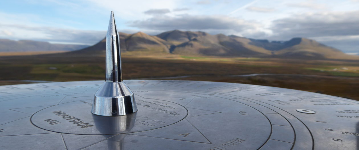
Cape Reinga is a deeply spiritual site for the Maori, and the DOC (Department of Conservation) has Maori guides stationed at the park ready to answer questions. Most of the guides we have seen during our month in New Zealand have been Maori’s and all of them have been friendly and ready with their stories. Quite often, they flow into speaking Maori and then have to translate for us. I am glad their musical sounding language has not been destroyed.

We are told that, at this most sacred site, out on a cliff, stands a single 800 year old Pohutukawa tree, named Te Aroha, that according to Maori legend, carries the souls of its’ people as they depart for the afterlife. The link will tell you more about that.

It is awesome to see this legendary and lonely tree still surviving and it does feel spiritual, even to us.
The Tasman Sea and the South Pacific Ocean meet in a visible line north of the light house, with different shades of blue waters headed right for each other, breaking into waves and then churning together.

It looks like a scary place to have to cross in a boat, even without the deadly rocks jutting out nearby.
A buzzing noise starts to intrude into my brain and as I look around for the source, Jeff tells me to, “look up, way up. ” Finally I see it, a square shaped drone cruising around, and then I locate the guy operating it. We wave to the drone as it takes our picture and then wander over to get a closer look as he brings it down to earth. It is a good one, homing in to base on its’ own when the battery gets low or you call it in. Usually they annoy the hell out of me but this guy is being careful not to buzz people too closely and the wind up here carries most of the sound away. Besides, the scenery is just to beautiful to let anything get in the way. We have seen many parks here where drones are not allowed, which I can appreciate. We can see a smaller cape to the west from the lighthouse hill without a drone.


There is a distance-to-places sign post by the lighthouse that everyone is getting their pictures taken at and one guy climbs onto the shoulders of another to put a flag on it.

We are as far North in New Zealand as we are going to get and the time to leave this wonderful country draws near. My least favorite part of any good vacation is when I first realize that I have to leave soon.
On the drive back down the peninsula we stop back at the 90 Mile Beach car park and walk down the middle of the shallow creek, between huge dunes, towards the beach.

Squeals reach our ears before we see the busload of tourists sledding down the huge sand dunes and across the creek. The dunes are steep, with a very long trek up to the top, and it looks like a pretty scary run, but we have done this before in Australia and don’t feel the need now. It is fun to watch them until the last bit at the bottom, where there is an abrupt turn onto the flat which looks harsh and possibly painful.

As we are walking the 3 kms to the beach, various 4-wheel drives pass us, splashing through the shallow creek and we decide there are just too many people around here. We decide to skip this beach and head south again, down the west coast towards some really big Kauri trees.
Kohukohu to Rawene Ferry
After meandering around some little country roads in the general direction we wanted we came to a dead end at a sizable bay. The road just ended at the water.

There was a woman sitting nearby who told us there would be a ferry after awhile and that it was a long way around otherwise, so we got out and waited with her. It was a small ferry, holding maybe six cars, and it ran mornings and evenings until dark so local folks could get back and forth to work.

It was almost Christmas and everyone on the ferry but us seemed to know each other and were wishing happy holidays. We were all dropped off on the other side in the small artsy looking village of Rawene, which I would have liked to spend some time in, but Jeff kept us moving.
Hokianga Bay
We worked our way down through the little bay side village of Opononi and out to the Waimamaku Coastal Track at the mouth of Hokianga Bay. The gathering clouds kept changing the light and there was a great view back towards the village.

We were getting hungry and needed to find a place to camp but this coastal park was too gorgeous to miss. On the other side of the narrow harbor mouth was a giant sand dune lit up by the sun and the water was a glowing blue

Looking out to sea was even better with a shiny pewter sea.

And then looking back up towards the signal tower (think modern lighthouse) hill…Hard to believe this was all at the same time.

There was sea-sculpted sandstone in colors of rust, with embedded balls of minerals…


And windblown shore plants with trails disappearing into them,

Unfortunately, it was getting late, and we had to leave this gorgeous place or miss out on a fresh fish dinner at the local pub tonight.
We stopped on the way and got a campsite at the Opononi Holiday Beach Park, a great little place that had goats tethered out to mow the grass and which wasn’t even listed in our guide books.
The local pub was just down the road and we got a table outside looking over the bay. A statue of Opo the friendly dolphin sits out in front. The link has a great old filmstrip about this famous critter, which is amusing to watch. I was enjoying a beer and watching a few small fishing boats coming back in for the night as we waited for dinner. The fish was good and fresh.
Back at camp we checked out the kitchen block which had a big covered porch and views of the bay. There were three huge handmade wooden tables made of single slabs of the most gorgeous wood, which I think was swamp Kauri.

We walked down to the water and watched the sunset over Hokianga Bay.

Day 26
In the morning , the baby goats were playing, jumping all around their mothers, bouncing off the banks. We stopped in at the info center on the way out where there was a long wall of murals outside about the history of Opononi.


One panel depicted the legs of the extinct 3 meter tall Moa bird. Another was about Opo. There were other panels about shipwecks, the signal light Kauri tree logging and Maori life.
We hated to leave, yet again. Places to go…things to see.
The Wooden Labyrinth
Next, we drive down a long, winding, gravel road through lush jungle-type greenery, with giant tree ferns and palm trees, and pull in at a sign for “The Wooden Labyrinth” puzzle shop. We are met at the door by Louie the puzzle maker, a happy man who hands Jeff a puzzle by way of greeting. Jeff works that puzzle out fairly quickly and Louie hands him another harder one.

While Jeff is working on that one he tells us he started out working on big Main Frame computers at age 19, back in 1969, and retired at 21, to make puzzles full time. He attends international puzzle parties every year where each person brings100 puzzles, and they exchange them with 100 other puzzle makers, so they each leave with 100 different puzzles from all over the world. He has thousands of puzzles in his shop, some his own creations, many from other places. Jeff was in heaven.

I talked with Louie and fed Mister Peacock bananas while Jeff made his puzzle selections. The elephant in the photo held a donation can for an elephant protection group. Then we went outside to do the maze. There were letter clues to collect to spell an answer to a riddle, and we ended up needing help to solve it, but it was fun. Our prize for finishing was a lollipop, which we didn’t deserve.
Mister Peacock showed us his beautiful tail on our way out.


-Wendy lee, writing at Edgewise Woods Gardens and Critters