For the Martin Luther King weekend we drove 3 hours out to our cabin in Pendleton County, West Virginia, taking our granddaughter Vivian with us. The weather has been so dreary for the past week, with grey, drizzly skies and temperatures stuck in the 40’s that we figured we’d mostly stay inside and play games. We had been hoping for some snow to play in. I usually prefer relaxing with a good book to board games but games geared to a six year old are easy enough to handle, in between chapters.
All day Saturday and then again on Sunday, we played board games; Community, Gathering the Garden, Snakes and Ladders, Quirkle, and Trouble. In between we all read or listened on our Kindles. I stoked the fire, tore out and rewound my old knitting, cooked and read a book but eventually the fog lifted, it stopped raining, and I had to get outside.
Wet Dry Run and a Movie
Dry Run was full of water for a change, so Vivian and I headed down the hill to check out the dam we had built last year. We had spent hours playing in the creek together, and our thrown up berm of rocks was still mostly intact. We can look forward to rebuilding the small breach when the weather turns nice in the spring. I wish the creek ran all the time but with all the limestone around here, it sinks into cave-y places pretty quick.
We kept walking down the paved road, past the big spring where the town of Franklin gets their water. This spring never dries up and there is a cement holding pond for them to draw from. The county ran 5 miles of pipe to carry this spring water into Franklin back in the 1960’s when the Hanover Shoe Factory was built out on Thorn Spring Road, and in the flood of 1985, they had to replace 5000 feet of it, as well as dig all the rock debris out of the spring.
Our place is located uphill from this spring so we collect rain from our roof into an underground cistern for our water at the cabin. So close, yet so far away… No complaints, it works fine for our needs.
4 Wheel Drive Track
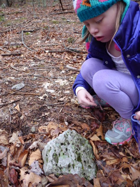
Continuing on our walk, we turned onto the hardly ever used, dirt lane that leads to an old hilltop meadow. We branched off at a 4 wheel drive track , back towards our hill, and then again onto the old logging road. This scenic route is much longer, but not near as steep a climb, as our driveway. Short legs only grumbled a little. It was a pretty long walk for her. We checked out lots of cool fossil rocks on the way as we followed the zig-zagging log trails back down the steep hillside to home.
We Break for Fossils
Saturday night we had introduced Vivian to the first Harry Potter Movie, which went over pretty well. She did not get too scared and we were looking forward to the second one tonight. There is no TV reception at the cabin but we enjoy watching DVD’s curled up on the couch by the wood stove. Wine and cookies work too.
Reeds Creek Fish Hatchery
Monday, after eating a yummy lunch at the Fireside Cafe in Franklin, we drove out to Reeds Creek Fish Hatchery. They grow trout to stock the lakes and rivers in West Virginia, using (and reusing) water from a huge spring. There are long, open concrete tanks set in the ground with a constant supply of cold spring water flowing through the thousands of fish. The fish are grouped by size and some of them are huge. The Golden Trout are the most fun because they are the easiest to see.
Golden Trout Plus a Hungry Looking One
The other trout we saw were dark, with spots, but I am not sure if they were Brook, Rainbow or Brown trout. When they see you coming they all start moving fast and jumping, expecting to be fed. Notice the dark one in the above photo with his mouth wide open. Visitors are not allowed to feed or touch the fish, but the hatchery gate is open until 3:30 in the afternoon and it is fun to watch them. When their fins breach the surface it looks like a whole bunch of little sharks.
Fish Troughs at Reeds Creek
It looks like a great place to find dinner if you are a Heron or an Eagle and I don’t know how they manage to keep them out. When we were there we didn’t see any dogs or anybody to ask. They were probably out stocking the rivers.
It is too bad that no one has built an Aquaponics greenhouse using the water from this hatchery. It would be a great way to make use of the nutrient rich water before it joins the creek. It is probably too far to a market where they could sell the produce, though. Someone would have to do a lot of driving.
We have an annual tradition of hiking on New Years Day, usually with our friends Tom and Carla. Last year at this time we were in Perth Australia, so we missed it. This year, Tom and Carla are in Vermont, so they missed it. In reality, none of missed anything, we just happened to do it elsewhere. We can catch up with our local friends later.
When we hike alone, we plan our hikes differently than when we have people with us. We tend to do out and back or loop hikes and keep it simple when it is just us. When there are four of us we might do a longer one way hike and park a car at each end. I thought maybe we might go out to Sleepy Creek Wildlife Management Area this year, since it is not far, but Jeff got to searching for hikes on the Tuscarora Trail in Pennsylvania instead. He came up with Cowans Gap State Park, a place we have never been.
Getting There
Check out this cool interactive Map I have embedded below. You can move and zoom in on the map from right here in my blog by left clicking and using the mouse. Cal Topo is a pretty amazing mapping website. You can do all kinds of neat things on it if you start messing around. We did the red dashed trail along the ridge from the Lake to Big Mountain. South along the ridge and back by way of the valley measured 9.6 miles on our GPS unit. It took us about 5 hours.
Cowans Gap State Park is about 13 miles North of Mercersburg Pa on Route 75 and about 50 miles from our home in Shepherdstown. It took us about an hour and 20 minutes to get there. There are some large, well kept Dairy farms up that way with beautiful views of the mountains and Buchanan State Park lands
Farmland to Mountains
You can see the ziggy white lines of Whitetail Ski Resort off to the left as you drive north. There is no natural snow yet but it has been cold enough the last few weeks for them to make their own snow on a couple of the slopes. We had a blast a few years back snow tubing there with family.
The temperature was hovering in the low forties when we arrived at Cowans Gap at 11:30 A.M. I was surprised to see a large lake with lots of trees around it when we arrived, and better yet, there was no entrance fee. We checked out the restroom building first thing and found that were prepared for winter visitors and keep the one family restroom nicely heated and the flush toilet functional.
Cowans Gap LakeThere was ice covering about two thirds of the 42 acre lake and finely graveled pathways all the way around it. Scattered in the shade of trees, along the fore shore, there were picnic tables and sturdy CCC built pavillions, a sandy volleyball court and a few really nice horseshoe pits.
CCC Pavillion
On the far side of the lake rose a densely wooded hill with lots of good fishing access. There are some steep hiking trails over there as well but we were going to do the Tuscarora Trail, on the East side.
Ice Covered Cowans Gap Lake
We had packed our water bag/ day packs with lunch and all the usual stuff: cameras, GPS, compass and head lamps. I carried my rain gear as well. I do not like worrying about getting cold and wet when the weather changes and it doesn’t weigh much. I wore light long johns, a vest and fleece, gloves and my trusty Ear Bags, which I always carry in my jacket pocket.
Tuscarora Trail-South
The blazed trail started just across the road and we immediately stated climbing, it seemed like, straight up the ridge. There were switchbacks and a some large sandstone rocks in the path and we could tell that this trail gets way less traffic than the Appalachian Trail, which is a good thing. The Tuscarora Trail was actually started because people were afraid they were about to lose a big section of the AT to development, which thankfully did not happen.
RockyTrail
We were ready for a breather by the time we reached the first little overlook on the ridge. My fleece was already off and hanging from my pack straps. Three young guys had passed us, wearing skimpy summer running shorts, the only people we saw for a good while. It does not take long to warm up when you are climbing a steep hill. I was beginning to regret my long john bottoms.
First View Towards East
We cooled off quickly as we hiked the more level, but still very rocky, narrow ridge until we came to a huge boulder field. It seemed that giants had dumped a humongous bucket of boulders up here on the top of the mountain, just so we could ponder how in the world they got here.
Rubble Field
The forest turned scrubby, pockmarked with stumps of trees cut for timber, as our trail merged into an old logging road.We walked through a grassy meadow with lots of open views east and west, then back into scrubby, cut over land with about 5 years of regrowth. There was a patch of Aralia spinosa, or Devils Walking Stick, which I do not come across very often.
Aralia spinosaClump of Aralia spinosa
Aralia is kind of ugly in winter, just a colony of ten foot tall, very spiny, but otherwise naked sticks. In August it will bloom with large, white, feathery pannicles and then the leaves will turn a nice burgundy and orange color in fall. Deer, bear and Cedar Waxwings like the purple berries. I realized this was the source of the seeds we had been seeing, in the weathered scat along the trail.
Log SlideTrailHead
The walking was much easier now, practically level with no rocks. We passed a couple of trails leading back down off the ridge that we might take on the way back. Our destination was straight ahead at that pointy hill, the lookout on Big Mountain.
Big Mt Overlook
Looking Down at Hogback Mt
Arriving at the overlook, we looked down on Hogback Mt, and back to the North, a long, long view of valleys and hills.
Looking North from Big Mt Overlook
To the South East we could also see a good ways. There used to be a fire tower up here but all that remains are some footers and the old outhouse pit back in the woods. There is a cell tower a few hundred feet to the south, which is the only one we can see from up here. Our walk was about 4 1/2 miles to this beautiful spot and we sat and ate lunch before heading back.
Big Mt Looking South East
I am glad we did not know about the graveled Tower Road coming up here before we decided to hike the ridge, but if you aren’t able to walk far, you can easily drive up to the Big Mountain overlook to enjoy the same view.
Western View From Cleared Section Below Summit
I don’t much care for repeating the same hike backwards, so after walking back North on the Tuscarora Trail for a little while, we turned left onto the old Log Slide Trail, down a seriously steep, narrow gully, with ankle-breaker rocks hidden in deep leaves. Our thighs were feeling the burn of each careful step by the time we got down to a paved road. We still enjoyed it more than backtracking. We walked down the side of the road, lined with small vacation cabins, about 5 acres apart, smoke rising from a couple of the chimneys. Cameron Trail came in from the west, and quickly branched onto Plessinger Trail, which followed the creek back to the lake. Walking in the woods by a creek is always nicer than being out on a road, even a quiet one.
Cowans Gap State Park has about ten rental Cabins tucked into the woods along the creek and there are shady campsites with central restroom facilities. The Creek is clean enough for brook trout and we saw signs of beaver. Rattle Snakes can be found here , according to a sign placed by the Park’s Nature Center. Did you know that Rattle snakes grow a new rattle every time they shed their skin, and in a good year, they can shed numerous times? So counting rattles does not tell age, if you ever get close enough to count them.
On a point jutting out into the lake there is a protective concrete bulkhead that allows for handicapped access to fishing and getting in and out of your boat without tearing up the shore.
Setting Sun on Ice
No gasoline powered boats are allowed, but you can use electric motors, which should keep the lake fairly peaceful. There was a sign board and rescue station for people planning on ice fishing or skating.
Ice Safety Sign
I like that they allow folks to play on the ice here in the winter. There is even an area where they monitor the ice for safe skating but it looks like you are free to go outside of it if you choose. I grew up on lakes and miss the freedom of exploring in winter from the vantage point of ice skates. Wild skating is a totally different experience than going around in circles on a rink.
The sun was getting low, the temperature dropping fast, and we were glad to be back before dark. The open water was very still, mirroring the quiet landscape. It was a good day, this first one of the new year.
Cowans Gap State Park (click link for a good website) was a refreshing surprise and a really well cared for park that I hope to return to in different seasons. With good hiking, boating, fishing and swimming, there is something here for everyone in the family.