This morning, while laying in bed, we watched a pickup truck drive all the way across the wide river bed to the railroad tracks on the other side. He had to zig all over the river bottom in search of crossings shallow enough for his truck. When we finally got up and opened the sliding van door we were met with a such a horde of sand flies ( giant gnat like things with huge teeth) trying to beat their way into our camper, that we high tailed it out of there without even making coffee first.
The plan for today is to go see the Tasman Glacier at Mount Cook National Park , stopping at interesting places along the way. Rakia gorge is an easy first stop along the road with no hiking needed for the views.
The second stop is way down a long, mostly gravel road, something like forty six kilometers, to hike around on a small hill called Mt Sunday, aka: “Andorras” , surrounded by huge mountains ( one was “Helms Deep”) and glacial rivers.
The Road to Mt Sunday“Little” Mt Sunday with BIG Mts in Back
There were only a few people there ahead of us and we pretty much had the place to ourselves, with some cows and sheep wandering about for effect.
Sheep Leading the Way
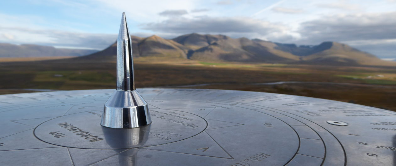
The Mt Sunday hill looked small until we started climbing it which took about 40 minutes and it was quite windy at the top, making our pant legs flap and snap like sails. The surrounding mountains looked huge and seemed close, but it would actually take days to hike into them. The sun was warming our little spot on the hill and it was a beautiful place to spend time just sitting there taking it all in, watching the weather move around in the peaks.
View from Top of Mt Sunday
On the way out, there was an entire herd of cows being moved down the road into a new pasture, using cattle dogs, pickups and people on foot. It was like swimming through cows as we drove slowly through.
We have noticed all the houses and farms have above ground water tanks and there are palm trees growing in all sorts of places, mixed in with eucalyptus and pine trees. It must not get very cold in the lower elevations of the South Island. Looking it up on a plant hardiness zone map it seems to be mostly Zone 8, which averages lows of -5 to -10C , or 12 to 20 degrees F, in the mountains and then zone 9 on all the coastal edges. I don’t think this takes into account the elevational changes in the big mountains though. In the eastern panhandle of West Virginia, we are in Zone 6b which gets a lot colder, with the average annual minimum being 0 to -5 degrees F, or about -17 to -21 degrees C. which is why we don’t get palm trees or giant tree ferns at home.
Single lane bridges abound, in the wide river valleys, posted with signage as to who has the right of way. It seems to be that heading upstream you usually give way to folks heading downstream. You cannot always see if there are people coming at you or not from the far side, and you have to go on faith. Sometimes there are lay-by’s in the middle. We are glad we are here in the (just barely) off season. A whole line of tourists could make these bridges kind of scary. Right now all we have to avoid are the sheep…and a few cows.
As we drive further away from the mountain ranges and again head south, the terrain progresses into fairly level farm land, with alfalfa fields and newly planted Kumara (NZ sweet potatoes). We start to pass incredibly large, aluminum piped, irrigation setups and then some giant rubber lined ponds that seem to be for warming up and settling out the seriously cold mountain runoff. We are on the “dry” side of the mountains, although maybe since summer is just starting, it does not seem all that dry yet.
We arrive at Lake Tekaupo, with beautiful (although invasive) lupines blooming everywhere, gorgeous turquoise blue water, and snow capped mountains in the distance.
Lake Tekaupo. Lupines
The Tasman Glacier is up ahead, further than it seems, because the mountains are so big in the distance. It looks like storms are brewing up in there but here, the water in the lake is intensely turquoise blue and the sun is shining.
Road to Tasman Glacier
Once we actually get all the way up the valley, the hike to the actual glacier turns out to be further than we are willing to go, especially since the clouds have gathered and it is now cold and rainy, so we don our rain gear and settle for climbing up a steep, stair step path for a view of the glacial pond and morraine dam at the closer end of the glacier. As with most glaciers these days it has been retreating for many years now and will soon be gone.
As we leave the Tasman valley, the glacier, and supposedly a view of Mt Cook, is completely socked in, but the sun slanting under the clouds lends even more color to the landscape around lake Pukaki.
Lake Pukaki in Tasman Valley
We settle for the night in nearby Twizel, ready for another day.
Tuesday Day 5
The hedges, the hedges. There are evergreen tree hedges everywhere (both leafy and needled) and about 30 feet tall, shaved on the sides to make them only a few feet wide. They are between every field and somebody has to go around trimming these things. It looks like a steady job.
Hedges Everywhere
We are now heading for the coast to check out the Moeraki Boulders. It is weird how sheep pastures have seaside views in New Zealand. There is so much coast and so few people that even ocean front property is farmland right down to the water. Sheep at the beach. I suppose if the water was warmer, people would flock there instead.
Moeraki Boulder Beach
The boulders are ancient concretions that have been washed out of the sand dunes where they were buried eons ago. Some of them have cracked open revealing the different layers of stone.
Inside a Cracked Boulder
Next we came to seals sunning themselves on the rocks. Lots of seals. And giant kelp swirling around.
Seal with Giant Kelp
Next, we have to drive through an actual town, Dunedin (pronounced doo NEE din) on our way to an Albatross colony and penguins. It is a city with the University of Otago, and a busy harbour and shipping port. We do not stop, although we get turned around on a road detour and end up at a castle accidentally. The gardens looked promising but it was closing time by then so we found our way back to the road.
Harbour at Dunedin, Otago Peninsula
Albatross are huge birds that look similar to seagulls and they fly right over your head very fast, so it was hard to get a good photo of one.
Otago Light and Albatross Cliffs
Albatross and gulls were flying around the lighthouse and zooming by right over our heads at this spot. We could see seals and dolphins and diving water birds down in the water and there were flowers blooming all around the cliffs.
It was getting late so we started south again looking for a camp for the night.
Please share and comment if you can. It is nice to know you are out there reading this.
On Sunday, we finally landed in Christ Church and shuttled over to install ourselves in our new tiny home, a bright orange, Spaceship camper van. The folks there showed us all the features and where to stash stuff and how to put up the tent, installed the DVD player and gave us some tips. We scrounged some leftover food and a couple of yoga mats from the free box (where previous Spaceship renters leave any extra gear or food) filled the water jug, plugged our GPS unit in, and headed out of town. We stopped at a gas station ( well, two because the first would not take our credit card) and then a grocery store for some basic foods (coffee, wine…) We needed to get used to driving on the left side of the road and negotiating all the round a bouts, which is easier to do on country roads. Luckily, it does not take long to get into country from town.
Green Hills, Sheep, No Trees
Within just a few miles we were rolling past velvety green, grassy hills, mostly covered in sheep, headed south east to the Banks Peninsula. Sheep would become quite the norm as days went by. I have never seen so many sheep, not even in Great Britain. Many of the lambs still had tails and looked about ready for market.
Naked outcroppings of volcanic rock and compressed ash layers jutted out here and there, along with greyed out stumps of long gone forests. The lack of trees on the steep hills was bothering me after awhile. In West Virginia, we would be worried about erosion with such naked hills.
Volcanic Rock and Ash Layers
There was a nice local art gallery on the way, and a “Silo Stay” accommodation next door that was intriguing, so we stopped there for a bit to browse. A metal sculpture garden led outback from a little shop where you could get a light meal. The Silos had been made into little cabins, with running water and everything.
We caught occasional glimpses of seaside cliffs and blue ocean down below and there were giant tree hedges outlining the fields everywhere. I have never seen such tall hedges and can only imagine the job it must be to trim them so neatly. That is two jobs I have never considered- giant tree hedge trimmer, tail docker…
We detoured down a narrow windy road, through the tiny village of Okains Bay, to stop at a Maori Museum. The docent was a Maori woman and the Museum ( in a converted cheese factory) housed a fascinating collection of Maori tools, boats, fishing baskets, sculptures, jewelry, artifacts and local history, and was well worth the stop. We were the only ones there and she told us to not worry about closing time- we could stay as long as we liked. Since there were about eight small buildings and a boathouse there was a lot to see.We learned that the Maori arrived in the banks area in the 1300’s and the European settlers not until 1850. The first Maori tribes were quite fierce, and they fought and killed each other, and some settlers as well, before finally settling down. They have since managed to assimilate quite well, while retaining their native language and some parts of their culture . The Maori did manage to kill off quite a few of the native birds, such as the 12 foot tall Moa, and the colonial settlers were responsible for bringing in all kinds of invasive plants and animals, which has destroyed many of the native populations. The only native mammals New Zealand originally had were three species of bats and several marine mammals, such as seals, sea lion, whales and dolphins. The country is currently attempting to protect what they have left with marine reserves and eradication efforts aimed at predators but it seems to be a losing battle.
Just down the road, at Okains Bay Beach Preserve, there were a couple of ancient shelter caves we stopped at next. There was a campground there too, but it did not seem to be open for the season yet, so we moved on.
We were getting seriously tired, so we drove the rest of the way down the peninsula to the Akaroa Holiday Park and got set up on the hill overlooking the harbour. We were finally on vacation.
View from Camp
There were only a few other campers and we had a great view of the harbour and village down below.
Sunset on Akaroa Harbour
We were sitting on what was once an ancient volcano that had blown out, forming the protected Akaroa Harbour at its’ center. Akaroa village is the oldest European settlement on the Island and retains some of it’s French influence and language. After enjoying the view and checking out the nice, clean camp kitchen and showers, we took a nice evening stroll down a little path through the woods and into the village, for a celebratory dinner of fresh fish at Ma Maison, watching the sunset over the water.
Akaroa, Riccarton, Castle Hill, Arthurs Pass-DAY 2
In the morning, we woke from a great sleep to a pair of friendly ducks and our first of many camp breakfasts of yogurt, fruit, and cereal. I snagged some instant hot water from the camp kitchen dispenser for my new morning staple of instant coffee mixed with hot chocolate. I am a lazy cook when I camp and did not have a coffee pot. I was impressed by the other folks who were being much more energetic and actually cooking, but I just wanted my coffee. The showers were our first lesson in the need for better planning. It helps if you have your soaps, towels and clothes ready in one kit each, with the next days clothes pulled the night before, and it is hard to share shampoo when you are in gender specific bathing areas. It was so nice to to be able to get a hot shower though, and remove the travel grime.
Jeff decided that he wanted to start heading towards Arthur’s Pass today, way up in the mountains west of Christ Church, so we folded away our little tailgate tent and started driving back out the Peninsula.
Our next stop, other than overlooks along the way, was at the Riccarton Bush native forest park in Christ Church, with 600 year old kahikatea trees and an impressive fence around it to exclude predators. This was an introduction to many of the native tree and fern species on the island, including giant tree ferns, my favorite.
Kahikitea loop Track in Riccarton Bush
Driving up the “Great Alpine Highway” towards Arthur’s Pass, our next stop was at Castle Hill, a hike through an odd outcropping of glacial worn, limestone boulders perched on a hill in a sheep meadow. Very cool. Parts of “Narnia” were filmed here. We had fun climbing all over the boulders, gazing out at the snow capped mountains in the distance.
Castle Hill Track with Snow Capped MountainsLimestone Boulders of Castle Rock
Cave Stream Scenic Reserve was right up the road and we stopped there and considered going caving. However, it involved entering the cave through cold water, at least waist deep, and by the time we emerged at the other end I would have been hypothermic and totally miserable. So we hiked over land to the entrance and the exit points and checked it out only superficially. It was a little disapointing but still worthwhile. Plus, there really weren’t enough hours in the day.
Cave Stream Exit
We continued on, getting closer and closer to the “Southern Alps” , which rise 920 meters above sea level at Arthur’s Pass. They really do look a lot like the Alps in Switzerland, with sharply defined rock faces, evergreens on the lower slopes and snow on the tops. The road started hugging the edge of extremely wide, braided gravel river bottoms, with blue-cold glacial melt water rushing by.
Braided Glacial Melt
There were numerous trail heads marking many different treks going off into the mountains, for which you needed some pretty serious equipment, such as climbing ropes and winter-ready gear. You could spend months just hiking the trails on the South Island. We were not prepared for a seriously technical trek and had just enough daylight left to hike to the Devils Punch Bowl and then Bridal Veil Falls before we needed to find a spot to camp for the night.
Devils PunchbowlView from Bridal Veil Falls
We camped right beside the river in a rough camp with nothing but an outhouse , too tired to bother getting out the stove and cooking. We ate some cheese and crackers and went to bed with the sound of the river running over rocks just a few feet away.
Camp by the River
A Kea bird, sort of a parrot, known for their inquisitiveness and their ability to remove valve stems and windshield wipers, landed on the roof and Jeff chased him away.
We sure did not need him punching holes in our tent.
The sun set on a good day and the river sang us to sleep.
Jeff made a color coded map of our New Zealand travel route, starting on the South Island at Christ Church through Picton, where the Ferry is. Each color is a separate day. although sometimes we backtracked so they overlap. We started on the East Coast of the south Island, headed South, then West, then North and East, then did the upper part last.
The second map, of the North Island, starts at Wellington, where the ferry lands, goes north to Cape Reinga and then backtracks south, ending at Auckland. From there we flew to Sydney and Perth Australia to spend Christmas/ New Years week with our daughter and her family.
The first map is the South Island. Be sure to go to the separate page titled New Zealand-December 2015 . The blog posts are categorized by New Zealand, then either North or South Island and I have tried to add the day number of our trip so you can try and keep them in order.
Each post has links (in green) for more information.
I hope you get to go yourself someday. It has been the most wonderful place I have experienced so far.
Also, if you are looking to rent a Spaceship, go to Spaceship
South Island Route-Christ Church to PictonNorth Island Route-Wellington-Cape Reinga_Wellington
Boathouse on Rainbow Lake
The glassy water mirrors a perfect picture of the tangerine sun setting in the western sky. Trees stand on their heads in the shimmering upside down land. A loon cries nearby, answered by one further off, the haunting sound skimming over the flat water. Absolute tranquility. Two mallards land out near the middle of the lake, circular ripples finally reaching shore with a quiet nod. A tiny puff of breeze riffles up and dies again, slowly rocking and bumping the boats below in their moorings.
Sitting out on the deck, the stars come out and then the entire Milky Way is visible across the sky. The sky is big and dark and there are millions of stars. A couple of cabins away, some kids are getting excited about maybe seeing UFO’s , but they finally get settled in around their campfire, their Dad softly strumming his guitar. Snatches of quiet song drift over and float away. A nighttime breeze moves in off the lake and cools the cabin down for bedtime.
Morning Fog
In the morning, a loon calls and a hot mug of coffee steers me out on the deck. Low fog is shrouding the lake as I lower into the Adirondack chair. As the sun rises, the downy cloud slowly floats upward, revealing a Great Blue Heron out in the shallows. He gracefully bends his long backwards legs then goes completely still. A lone duck swims quietly by, a V trail marking his wake. By the time sunlight reaches the far shore I am down on the yoga mat, getting ready for the new day.
Sunrise On the Far Shore
After a breakfast of yoghurt and local peaches, it is time to explore with a relaxing paddle across the lake. The weather is just right, warm and calm. We lower ourselves into our boats for an easy glide over silky water. We head for the long, esker island, from a long ago glacier, that divides Rainbow Lake lengthwise. There are some cabins out there that are only reachable by boat in the summer. Some are small, rustic summer cabins, simple little hideaways, but there are a couple that look like they might be substantial enough for four seasons. In the winter folks have to traverse the frozen lake on foot or snowmobile (called sleds up here) to get out there. Last year it went down to 40 below zero, and high winds drifted the snow waist deep on the leeward side, scouring the land dry on the other. Sounds brutal, but maybe wonderful, to feel this place in the winter, hear the high shooting sounds of ice expanding, as long as you can cozy up to a nice warm wood stove.
Small Beaver Dam
Paddling out around the other side of the island, towards where a small creek flows in, and then zig-zagging upstream, there is a beaver dam, and it looks like a dead end. Back tracking into the lake again, we spot a tiny break out on the esker just big enough to get a boat through. It turns out to be a nice picnic spot with good sitting rocks and a fire pit that looks out to a section of lake where there seem to be more people and boats.
Break in the Esker
A family comes through the gap in four well-crafted kayaks in purple, red, green and yellow. We admire them as they go through and are told they are made of rosined fabric stretched over wooden frames, and weigh only 25 pounds. They seem to be perfect lake boats, easy to maneuver and light. I would not want to take them through a rocky river though.
Path to Pond
We finish lunch and paddle up the other side of the island to where there is a place to pull canoes or kayaks up on shore with a trail heading off through the woods. The path is barefoot-soft with pine needles, winding through an amazing array of picture perfect fungi, and ends at a secluded pond with an empty campsite and a spare boat ready for fishing. We enjoy the peace and quiet for awhile and then retrace our steps to the parked boats. We could spend days exploring all the nooks and crannies on this lake. When the shadows start to lengthen we find our way through the water, back home to another beautiful warm evening, and a tiny slice of moon added to the sunset.
Awakening to another new day, we fill our water bags and pack food for a drive out to the Loon Mountain fire tower trailhead. Boating one day and hiking the next evens the muscles out- kayaking works arm muscles, hiking up mountains works legs and heart- especially a steep hike. The first part of the hike is an easy grade up an old logging trail until the blazed trail turns off and suddenly narrows into a muddy, rocky footpath. Moose tracks, only a day or so old, are pointed down as the trail heads up. Someone has been doing a lot of trail maintenance on the initial steep part, building footbridges over mossy, rocky waterways and past a few small waterfalls. After five or six little bridges the path gets seriously vertical and the trail climbs right up the middle of a drainage, gaining 1500 feet elevation in the process.
Yellow Mushrooms
There are lots of colorful mushrooms and wet mosses, and it is much damper than you might expect, considering the rocky elevation. This hike was called “moderate” in the hiking book but the second half of it is fairly difficult, both for footing and for pitch.
We finally reach an almost level path, where the shady woods gives way to a sunny, rock bald at 3340 feet elevation. There is a fantastic clear view from up here which makes it worth the trek.
Loon Mt Fire Tower
The fire tower, a decrepit, rusty, erector-set-looking thing perches on the bare rock. The tower stairs have been removed but you can see fine without any more climbing. There are full views to the North, East and South. There is something barely visible on the horizon to the North. Zooming in with a camera, it turns out to be windmills on a ridge way out in the distance. Otherwise, there is a just a hint of a gravel road and a barely visible bit of power line cutting through the endless layers of green hills and flashes of lakes.
View from Loon Mt
For some strange reason, there is a cloud of giant drone-like damsel flies hovering around the summit while we rest. They won’t sit still long enough for me to get a decent photo and it is hard to figure out why they are up here. One hawk cruises by, a little ways off, at about eye level, but that is about it for visible wildlife. After the exertion climbing up, we aren’t really hungry for our lunch, so we nibble on a few pumpkin seeds and cherry tomatoes, and drink some water before heading back down the way we came.
Loon Mt View West
There is a side trail on the way with a view to the West so we detour over. From there we can see more lakes and even more green hillsin the distance. The total hike is 5.4 miles long on our GPS and takes us 4 hours, including the nice rest we had at the top.
By the time we get back to the car, we are drenched in sweat, so we change into dry clothes for the next leg. Our guide book says there are board walks on this short hike to a waterfall called High Falls, so my hot hiking boots get pulled off and replaced with sandals and a skirt. The “boards” turn out to be hand-hewn logs draped across the muddy patches, and the walk is an easy mile through the woods along the Salmon River. We pass no one on the way in. There hasn’t been anyone on the trails with us all day, actually. There are a few nice cascades along the way and the biggest waterfall is about thirty feet high and fifty feet across , with massive amounts of slightly tannin colored water flowing over it.
High Falls
It would be a nightmare to go over in a kayak, but somebody brave or crazy has probably done it. At the bottom of the thundering falls the water makes an abrupt left hand turn and races downstream without bothering to stop and form much of a pool. There is a large, solid landing of rock to hang out on down at the bottom, facing the falls. It is not a very good swimming hole, too much volume and speed and churning about. Someone has built a throne of rocks to sit and gaze from on and we take turns sitting there for awhile, absorbing the sound and feel of the water. It is a great waterfall, mesmerizing to watch.
On the way back we pass a woman with two kids wearing swimsuits and carrying towels. They ask if they are headed the right way for the falls. We say yes, and then wonder later if we should have warned them about swimming there. Hopefully they were careful. We passed the dad a little further upstream, fishing.
Once back at the car we stick to the paved road, instead of the wash boarded gravel we came in on, and happen upon a little village on a lake with a sign for 24 hour gas, which seems like a good idea. There aren’t that many places out here to buy gas and a whole lot of back roads to use it up on. It turns out to be just a big gas tank with a single electric pump, set out back of a not-very- lucrative-looking store, but the lonely machine took our credit card and we felt better for having topped off our tank. There is a For Sale sign on the deserted building and another sign in the big dirt parking lot that says “Parking for sleds and ATV’s only”. It took us a while to figure out that a sled is a snowmobile and that in the winter it gets crazy with them up here. We get home just in time to see another nice sunset from the deck.
The Tiny Boathouse
We must be finally relaxing, as we are getting up earlier in the morning now, sleeping deeper and more rested. Sunrise is not directly visible from our vantage point in the boathouse as it looks south and hugs a hill on the east side, but the lake is beautifully serene each morning, still and glassy, as the ducks and loons begin to talk and move about. Today we are resting up somewhat and going to the Wild Center Museum down in Tupper Lake. We have heard it is definitely worth doing.
As we are getting ready to leave, our boathouse owner comes walking up the path from his other boat house -he has three tiny ones in a row. The other two are more like boat garages on the water, no rooms above it like ours. He has a friend with him and they are in the midst of a recycle run after having his son’s family visiting for the past week out on the island. New York pays a nickel for each can and bottle you bring in, but you can’t crush the cans, they have to be able to read the bar scan. We ask him how the boathouses and docks faired in the winter, with all the ice heaving and snow, and he says they take a lot of work to maintain every year, and basically have to be constantly rebuilt. Last winter the ice grew 3 feet thick and it pushed a lot of the docks and boathouses askew. He pointed out a couple we had seen that were all jacked up on one side and leaning. It is just something you have to deal with and get used to around here.
When we get to the Wild Center it has a big field roped off with flags for parking and looks like a county fair sort of celebration going on. It turns out that they have just opened up a whole new exhibit area this July 4th and are getting a lot of new visitors because of it. The new part is called the Wild Walk and after buying our tickets ($20 each for adults) we decide to do it first. The Wild Walk is a tree top walk over raised boardwalks and swinging bridges leading to alcoves depicting different animals habitats.
Spider Web on Wild Walk
One has a giant spider and web, made of ropes and netting stretched across a hole in the deck, that you can climb around on which is fun. Nearby displays teach cool spider facts. Did you know that static electricity plays a role in attracting insects into spider webs?
Eagles Nest
Another area has a giant stick-woven Eagles nest, built up high on stilts, with stairs leading up and viewing spots of different mountains. There are swings hanging down below and a swinging bridge takes you to a giant hollow tree trunk with all sorts of hidey critter homes in it. The rendition of the tree looks and feels incredibly real. There are realistically carved creatures, lurking in nooks all along the walk. One is of a porcupine and the artist is in the process of adding others on the massive wood posts supporting the walk structure.
Porcupine
Metal is also creatively used and the whole thing is great fun for kids (and big people) to explore and play around on.
It is getting pretty warm by now, being right at noon, so we head down a trail, through shady trees, onto two docks overlooking a marshy section of an oxbow on the Raquette River. There are too many people around to be able to see any otters and it is probably siesta time for most critters anyway. We had paddled on this same river the last time we were up here, but had not done this section. The St Regis Outfitters in Saranac Lake will rent you a boat or they can shuttle your boats if you want to use your own. Or you can paddle upstream from various put ins and float easily back down, the current is not hard. A boat is a good thing to have up here and there are lots of places to explore.
Next, we walk back around to the Museum by way of a manmade but natural looking pond that butts right up to the south side of the building. This property was once a commercial sand pit and they have used the already open space to create a wild looking pond and marshy area, with native plants and turtles and frogs. Once inside the museum, we realize that the floor sits below water level of the pond and there are huge windows, with wide wooden ledges and stools, looking out over the water. We buy a soft pretzel with maple mustard and drink some free water to cool off. The museum has a daily schedule of different live animals being brought out with an interpreter. When we first arrived it was a snake, and now, some turtles. Live river Otters come inside to their natural looking splash pool, from their private refuge outside, every day at 2 pm, and we are mesmerized as they glide around below water. You can get right up to the glass and watch them enjoying themselves, barely moving their limbs as they move underwater, pushing off rocks, rolling around and then slipping to the surface for some air and back down in one smooth motion. I could watch River Otters all day.
The Wild Center is full of interactive areas for kids to touch, smell, and hear woodland critters. They can grind on some rock like a glacier, put their hands in trickling streams of water, or even paint pictures. There is a search game to follow along, and lots of live fish and turtles and frogs in natural habitats.
3D Globe
There is also a huge, interactive, 3D globe suspended in the middle of a room that will show you about 800 different world happenings in real time. It will light up every place in the world that is having earthquakes, show the ocean currents and temperatures, and volcanoes that are erupting right now. There are shark tracking routes, radioactivity patterns from the Japanese earthquake, tsunamis’, hurricanes, even other planets. We spent a lot of time in there as there were so many different programs and the interpreter was very good at controlling the program. If no one is interpreting you can also control it yourself from a touch screen. The Wild Center is a great place for families to spend an afternoon and everyone will enjoy it. It is a fun way to learn and not stuffy at all like some museums can be. You can break up the inside and outside time as much as you need so you can keep the whole family happy.
There is so much to write about our trip that there is a second part coming later.
I was reluctant to go backpacking. Packs are heavy when you carry your sleeping bags and tent and food and all. It was supposed to rain with Hurricane Bill coming up from the Texas Gulf, aiming right at West Virginia and likely to get stuck in the mountains. But, I pushed myself to go because I have not been much fun lately and obviously need a kick start. Jeff did all the work of planning for us with his amazingly detailed lists of things to pack. Luckily we pared it back down when we realized how much it would all weigh. I can do 25 pounds all day but do not want to go over that and Jeff carries the tent, which is the heaviest thing, even though it is fairly light. His lists actually have weights on each item. Still, we should not have carried as much water as we did, considering how wet it was, and we ended up dumping a lot of it. We were planning on only two nights camping, not a big deal.
Rock Cairn at Dolly Sods
Dolly Sods is about three hours from home but we stopped in Winchester for some doctor’s appointments on the way. We drove out Route 50 west to 259 south and then Route 55. When we finally got to the top of the mountain the clouds were looking ominous but scudding by pretty fast. We wanted to see the view from Bear Rocks, since it was early yet, but as soon as we got there the clouds decided to roll into a thick foggy ground blanket, and it started to rain. So much for that idea. We drove back to the trail head parking area, where the sun came back out, so we loaded up and headed down the trail to the campsite along Red Creek some friends had already claimed for our group.
Laurel Flowers
Mountain Laurels were in full bloom all over the place. They always
make me happy
because as a kid they were always blooming on the last day of school so I think of them as the beginning of real summer. Their
Kalmia blooms
flowers are geometrically gorgeous with many shades of pink and the coolest UFO like shapes. Low bush Blueberry plants were scattered all through them and I was glad they were not ripe yet because I did not want to disturb any foraging bears. The cloudy skies and being up at 3800 feet kept the air from being too hot but the trail was fairly muddy going in. On some sections stepping stones had been laid which helped keep our feet dry but it was tiring to keep adjusting our stride to fit the spacing. We only hiked about a mile and a half to the campsite where our group was setting up and crossed only two creeks on the way. No rain yet. I was still glad we weren’t hiking a lot further. We are both out of practice wearing a full pack. We visited for a while at the group tarp and wandered around looking for a spot for our tent, not too close to the creek. We settled on a tight little space under some hemlocks on the other side of the creek where we would still be able to get out if it flooded. It started to rain again as soon as we settled in and after having a little snack of walnuts and dried apricots we went to sleep with the rain gently splattering on the thin nylon roof.
There were some small leaks that night (right over my head of course) while it poured but it wasn’t bad during the light stuff. We adjusted, but in the morning we decided one night in the tent was enough for now. We had been here before and could come back and hike in dryer weather. The trail was seriously muddy on the way out and much harder to walk on. We were looking forward to spending the next night in a comfortable bed in our nice dry cabin only about an hour away. We are into comfort more these days. When we got back to the trailhead we were surprised to see a whole bunch of people running down the dirt road towards Bear Rocks in some kind of race.
Bear Rocks Fog
We maneuvered our car around them and tried Bear Rocks again but the clouds would not part long enough for us to see anything so we gave it up. The dash thermometer climbed 13 degrees as we descended into the valley and we stopped at Seneca Rocks to change into shorts and sandals. On the way to the cabin we stopped at the Fireside Café in Franklin for fresh barbecue. West Virginia and US flags fluttered on every other light post all the way down Main Street for West Virginia day.
It rained on and off all day Saturday, about once every hour, and we were nice and cool out on the porch reading.
Sunrays in Misty Woods
It had been 90 some degrees when we left Winchester on Friday afternoon so we were glad to be in the mountains where it was only in the low 80’s when the sun was out and way cooler at night. I was hoping to see a Luna moth again, since it is about the right time for them, but I guess they don’t fly in the rain. Last year they came to the cabin window at night in mid June.
We had some hard rain Saturday night and spent a few hours Sunday re-trenching drain bars on our steep driveway and then went down to the creek, which was actually running, and messed around building a rock dam for a wading hole. I kept my hiking boots on so they could get cleaned up as I played in the water. Our creek is called Dry Run for a reason. The water tends to run underground by us unless there is a good fresh rain. The town pulls their water from a good spring just below us though and it never runs dry there.


 We learned that the Maori arrived in the banks area in the 1300’s and the European settlers not until 1850. The first Maori tribes were quite fierce, and they fought and killed each other, and some settlers as well, before finally settling down. They have since managed to assimilate quite well, while retaining their native language and some parts of their culture . The Maori did manage to kill off quite a few of the native birds, such as the 12 foot tall Moa, and the colonial settlers were responsible for bringing in all kinds of invasive plants and animals, which has destroyed many of the native populations. The only native mammals New Zealand originally had were three species of bats and several marine mammals, such as seals, sea lion, whales and dolphins. The country is currently attempting to protect what they have left with marine reserves and eradication efforts aimed at predators but it seems to be a losing battle.


